Why a Field Boundary Can Carry More Than One Story
Field boundaries reveal present-day uses and possible traces of older land patterns. Learn how to read hedges, ditches and fences without mistaking clues for proof.
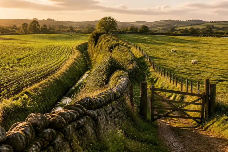
The most common mistake when reading a field boundary is to treat it as a clear line between two kinds of land. That shortcut can make a hedge, ditch or fence look like the result of one decision, when it may still divide work, follow an older pattern and accommodate newer uses. To understand a field boundary, begin with what it does now and build outward from the visible clues.
Start with the working edge
Walk along the boundary where access is permitted, and notice its materials before trying to explain them. A wire fence, dry-stone wall, earth bank, hedge, drainage channel or combination may divide grazing from crops, keep animals out of a lane, mark a property line or channel water. Those jobs can overlap, but the feature itself rarely identifies which one came first.
Look for practical signs on both sides. A gate facing a track suggests a route for moving livestock or machinery; a ditch may help water drain from a cultivated field; a broad verge can leave room to turn equipment. These clues support a reading of present use, not a claim about the boundary’s origin.
Problems arise when a feature is judged by its appearance alone. A neglected fence may still be a legal or working division, while a neat hedge may have been planted for shelter, privacy or wildlife as well as enclosure. If the boundary seems to have no obvious function, note that uncertainty rather than treating it as evidence of a vanished purpose.
Read the joins
Boundaries often make more sense at their meeting points. Follow a hedge to a lane, stream, woodland edge or neighbouring field, and notice whether it continues, bends, stops abruptly or changes material. A line that carries on across several parcels may reflect a broader division; a short section beside a gate may serve a narrower task.
Changes in height, alignment or construction are useful clues, but not ready-made dates. A bank beneath a hedge might indicate that the hedge grew on an older earthwork, or it might simply have been shaped during maintenance. Likewise, a stone wall that becomes wire fencing could mark a change in how the edge is managed without telling you when or why it happened.
One common snag is to assume that a straight boundary must be recent and a crooked one ancient. Straight lines can follow streams, roads or practical field layouts; irregular edges can result from later adjustments. Compare the feature with its immediate surroundings before drawing a conclusion.
Look beyond the line
A field edge is not always a clean separation. Hedgerows can provide shelter and habitat, ditches can carry water, and verges can support plants that are absent from the field interior. The same boundary may be useful to a farmer, a neighbouring landholder and local wildlife for different reasons.
That shared value can also create friction. A ditch that drains one parcel may affect another; branches may overhang a track; a hedge may be retained for shelter while making a field harder to access. When a boundary appears to serve several purposes, ask who uses it, who maintains it and who might be affected by a change. Avoid assuming that visible care or neglect reveals who owns it or who is responsible.
Ownership and maintenance responsibilities can be difficult to establish from appearance alone. Where a real decision depends on them, consult relevant land records, agreements or the local authority, and seek appropriate professional advice if needed.
Notice change in place
Comparing a boundary with its neighbours can help explain how land use has shifted. A thick hedge beside open fields may be retained for shelter or wildlife; a fence crossing an older bank may allow a different form of enclosure; a widened gate may reflect a need for easier access. Each clue suggests possibilities, not a complete account.
Say you come across a grassy bank carrying a sparse hedge, with a newer-looking gate opening onto a field used for grazing. You note the bank, hedge, gate and current use separately, then compare the line with nearby boundaries and an older map held by a local library. Suppose that map shows a similar line, but no detail about the gate: you can reasonably record that the division appears on both the ground and the map, while leaving the gate’s age and the boundary’s original purpose unresolved.
Maps are useful when treated as records of particular moments rather than final answers. Compare a current map with older editions available through a local library or mapping service, paying attention to whether the line shifts, appears, disappears or stays in place. A mapped boundary may be omitted, simplified or drawn for a different purpose, so check the map’s date and conventions before interpreting a mismatch.
What can boundary clues answer?
Does a hedge prove an old boundary?
No. A hedge may have been planted later, replanted after damage or retained for a practical purpose. Look for other clues along its length, such as a bank, ditch, track alignment or matching line on an older map.
Can a fence tell you who owns the land?
Not reliably. Fences can be maintained by someone other than the owner, and ownership lines do not always follow the most visible barrier. If ownership matters, consult land records or seek suitable local advice.
What should you do if a boundary has changed?
Record what you can see now and compare it with nearby features or available maps, without assuming a single cause. A new gate or altered fence may reflect access needs, changed land use or repairs rather than a shift in ownership.
Must a boundary be a physical feature?
No. A division may be shown on a map or understood through an agreement even where the ground offers no obvious fence, hedge or ditch. Treat the visible landscape and documentary records as different kinds of evidence.
Make a careful reading
A useful field-boundary note separates observation from interpretation. For each item below, record what you actually see, then let the result guide what to check next rather than turning a clue into a claim.
- Observe whether the edge is a hedge, wall, bank, ditch, fence or combination; if its material changes, note where, then compare that join with nearby boundaries.
- Observe what meets each end, such as a track, lane, stream or another field edge; if the line continues, compare its route across the landscape, otherwise record where it stops.
- Observe the land uses on both sides and the position of gates or gaps; if they provide access between a track and field, note that practical function, otherwise leave access purpose open.
- Observe whether water stands in or flows through a ditch; if it appears to drain a field, record the direction only when it is clear, otherwise avoid assigning a drainage role.
- Observe whether the boundary’s alignment or materials match nearby edges; if they do, compare the pattern on a map, otherwise treat the difference as a clue rather than a date.
- Observe the date and stated purpose of each map consulted; if it depicts the boundary, compare its alignment with the ground, otherwise do not treat its omission as proof that the feature was absent.
- Observe whether you have documentary evidence about ownership or maintenance; if not, keep both as open questions, and if a decision depends on them, consult relevant records or a qualified professional.
The most revealing field boundary is not always the oldest-looking one. A careful field-boundary reading can show how practical work, inherited patterns and present-day uses sit together, while leaving unanswered questions in view until better evidence turns up.